

|

|

|

|

|

|

|
||||||
Topographic Surveys |
||||||||||||||||||||
The purpose of a Topographic Survey is to gather data about the natural and man-made features of the land, as well as its elevations. From this information, a three-dimensional map can be prepared. These maps aid in architectural and engineering design. A topographic survey or a topo survey is a survey of the natural and selected man-made features of a portion of the earths surface by remote sensing and/or ground measurements to determine horizontal and vertical spatial relations. They are typically used for graphically depicting the surface of a particular parcel of land and any man-made features and elevation changes. A topographic survey may be tailored to suit the needs of the client. A topographic survey may show contours at one, two or five foot intervals. The smaller the contour interval will result in more field measurements and higher cost. A topographic survey prepared by Manzie & Drake Land Surveying will include at least the following items: |
Examples: |
|
|
|
Click the following image for an example of a topographic survey performed by Manzie & Drake Land Surveying. 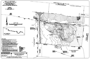 |
| |
|
|
Home | About Us | Scope of Service | Photo Gallery | Why a Survey? | Cost | Clients | Links | Employment Copyright ©2009 Manzie & Drake Land Surveying - All Rights Reserved | ||||||||||